
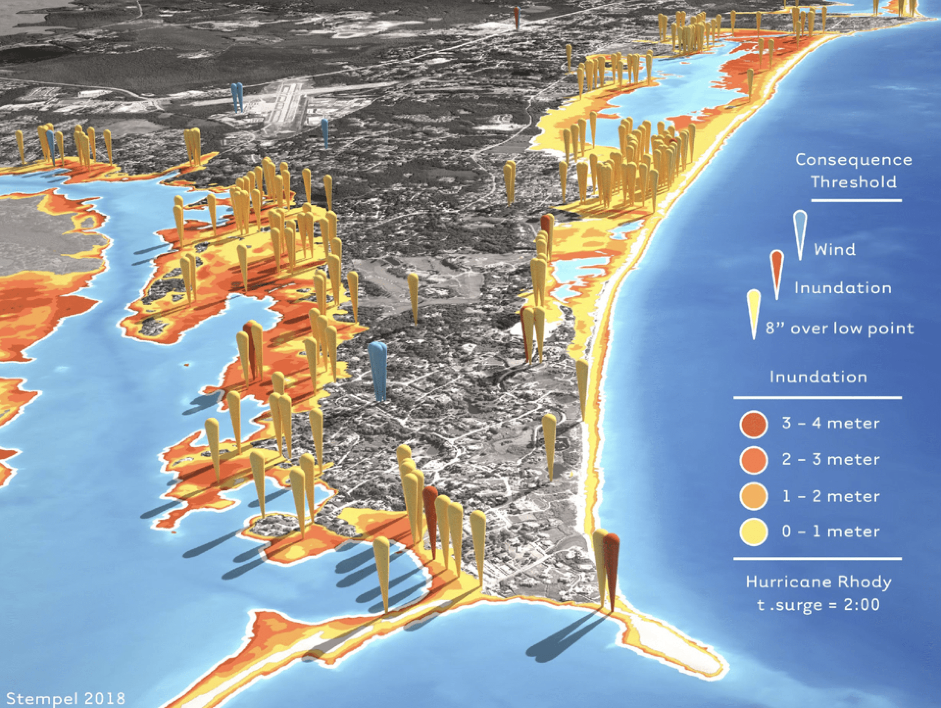
Photo courtesy of Isaac Ginis | The model demonstrates how flood waters will rise given a hurricane in the state of Rhode Island.
As catastrophic hurricanes wreak havoc along the coast, a professor at the University of Rhode Island is working to develop models to predict the severity hurricanes have on a specific area. These models are so specific that they can simulate the impact these storms have on specific streets.
Isaac Ginis, a professor at the University’s Graduate School of Oceanography, is leading the team that looks to build the prediction models. The team also includes Austin Becker, an assistant professor in the University’s department of marine affairs, several graduate students and state officials. In addition, there has been a collaboration with the Rhode Island Emergency Management Agency (RIEMA).
The project contains various model components that depict different aspects of a hurricane. Each hazard of the storm, including wind speeds, coastal flooding, inland flooding and the impact on infrastructure is simulated by a separate model.
Becker said the team is not acting as meteorologists with the prediction models, but are using them to determine the trajectory and size of the storm as meteorologists would. The team intends on using the devices to determine how hazards associated with the storm will affect specific areas. “Our part is predicting the impact of the storm and the consequences it has for communities and society,” Becker said.
The models being developed have a three-dimensional component that helps to visualize the potential hazards from the hurricane. “This will be able to help the emergency managers, decision makers and first responders to more easily see the potential impact to different critical infrastructure and that will help them to get better prepared,” Ginis said.
The prediction models being developed have a smaller spatial scale of 10 meters, which is smaller than the larger weather models scale of five kilometers or more. This will allow individual structures to be visible.
Showing the impact on individual structures will help emergency management officials to make safety-related decisions, which Ginis said is one of the most important aspects.
“We want to be more specific in terms of the threat going down to the places where people actually live,” Ginis said. “For example, if you’re very specific that a particular road will be flooded, you’ll know as a result, emergency vehicles may have a more difficult time reaching people.”
With the new prediction models, officials will also be able to better inform residents about dangers they could potentially face. Ginis said residents often don’t adhere to warnings about generalized threats.
“To make sure people are very informed about potential hazards and threats, what we’re trying to do is more local, more specific and more visual in presenting the particular risks,” Ginis said.
Additionally, the prediction models will simulate hypothetical storms to assist with practice emergency preparations. Last year in June, Ginis said RIEMA conducted four days of training with 160 people based on the prediction model’s computer simulations of a hypothetical storm. The training was done in collaboration with the Department of Homeland Security and the National Weather Service.
The training simulated a hurricane named “Hurricane Rhody” making two landfalls in Rhode Island. Ginis said the scenario involved significant challenges that local officials would have to plan for.
“We considered all the potential kinds of impacts, from the winds, from the storm surge, from inland flooding,” Ginis said. “We looked at downtown Providence, we looked at the impact of a hurricane on the Fox Point Hurricane Barrier.”
The simulation of “Hurricane Rhody” showed the flood risk from such a storm. For example, Ginis said the Fox Point Hurricane Barrier would have its gates closed before an incoming hurricane to protect against storm surges. However, he said closing the gates of the hurricane barrier could create a lake on the inside of the barrier as the rivers in Providence flooded. The prediction models showed this could result in a flood of up to 15 feet in downtown Providence from river flooding alone.
“These are the kinds of scenarios that we can do simulations with the computer model that have never happened but could happen,” Ginis said. “Emergency managers can see those potential scenarios and develop action plans.”
Becker hopes that the prediction models can be used as examples for why advanced preparation for storms is needed. He said if officials can better understand different scenarios, then a more convincing argument can be made for long-term investments to make areas more resilient to storms.
While this will initially be used by RIEMA, state and local officials and the Federal Emergency Management Agency, both Ginis and Becker believe a similar type of system could eventually be used in other coastal states across the United States.
The prediction models for Rhode Island are mostly finished. The project has been given two more years of funding by the Department of Homeland Security. The team is now working to cover Connecticut and Massachusetts in the prediction model’s coverage range. Ginis hopes after the current funding period is over, the prediction models will be fully ready for use.